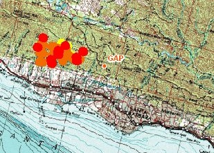
Here’s the latest MODIS-based map of the fire, which you can obtain as well, staring on this page:
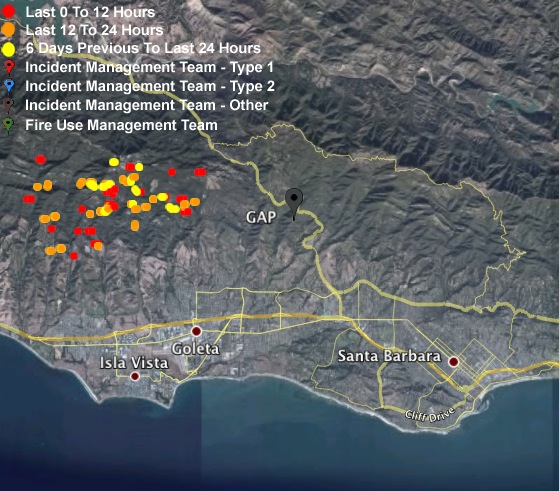
Here is the latest Google Earth image, with .kmz data from ActiveFireMaps.fs.fed.us:
To their credit, KTMS/990am and 1490am are covering the Gap Fire live, between national Fox newscasts. (Though they just broke into one to cover a press conference live. They’re talking about maps and other resources, but with no references to where those might be on the Web. Also Edison “had a harrowing time” getting power back up.)
Other items from the press conference:
- The Gap Fire is the top priority fire in California, because of its threats to populated areas.
- West Camino Cielo (which runs along the ridge) is a workable fire break, should the fire start heading North. The fire so far has been on the south, or city, side of the ridge. If it jumps the ridge, it will be bad on the north side, where the Santa Ynez valley spreads below. This is the valley that starred in the movie “Sideways”.
- Goleta 4th of July fireworks and other events canceled for tomorrow. Can’t find the city website, but the guy on the press conference says it refers to other sites anyway. He also said that the city’s new Reverse 911 system is ready, though new and untried. He’s also begging people to stay away from viewing the fire from Cathedral Oaks Road (the main drag below the mountains where the fire is burning).
Now KTMS is breaking away. Says 2400 acres have burned so far. KTMS has no live stream, far as I can tell.
The News-Press‘ radio station, KZSB/1290, can be heard via Windows Media from a link on the home page of the newspaper. But while KTMS and KCSB were covering the fire live, KZSB was airing an interview with a guy who’s pushing for offshore oil drilling. For what it’s worth, it was a major oil spill from an offshore platform here in Santa Barbara in 1969 that gave birth to lots of protective legislation, as well as Earth Day and much of the environmental protection movement that has peristed ever since. Odd choice, odd timing. KZSB may be the only news station in the whole country lacking a website. Sad.
For up-to-date fire maps from a national perspective, with satellite coverage by MODIS, go here. More:
- MODIS Active Fire Map (national, choose a regional map from here)
- MODIS California-Nevada map. The .jpg, the .pdf. Note that you can get a .kmz file at the MODIS Active Fire Mapping Program, and open it in Google Earth to produce visuals like the second image below.
- Active Fire Map viewer. It’s interactive, but not too intuitive. Check-box the layers you want, draw a box around the area you want to see. Zoom in, zoom out.
- InciWeb’s site for the Gap Fire.
- County of Santa Barbara’s home page. Has current information, but no direct links to any. New info on the home page wipes out the old. It’s a site, not a blog. Static Web, not Live Web, alas.
- For live coverage on the Web, check frequently with KCSB. The stream selection is here.
Tag: sbgapfire.
Leave a Reply