Eighteenth in the News Commons series
Second on the #LAfires
8:02pm It appears that water dropped on the Sunset Fire has mostly contained it within a perimeter absent of houses. Good that the winds were not too high to allow that work. I also no longer see the Chinook operating on FlightRadar24, which may mean its air tanker work is done.
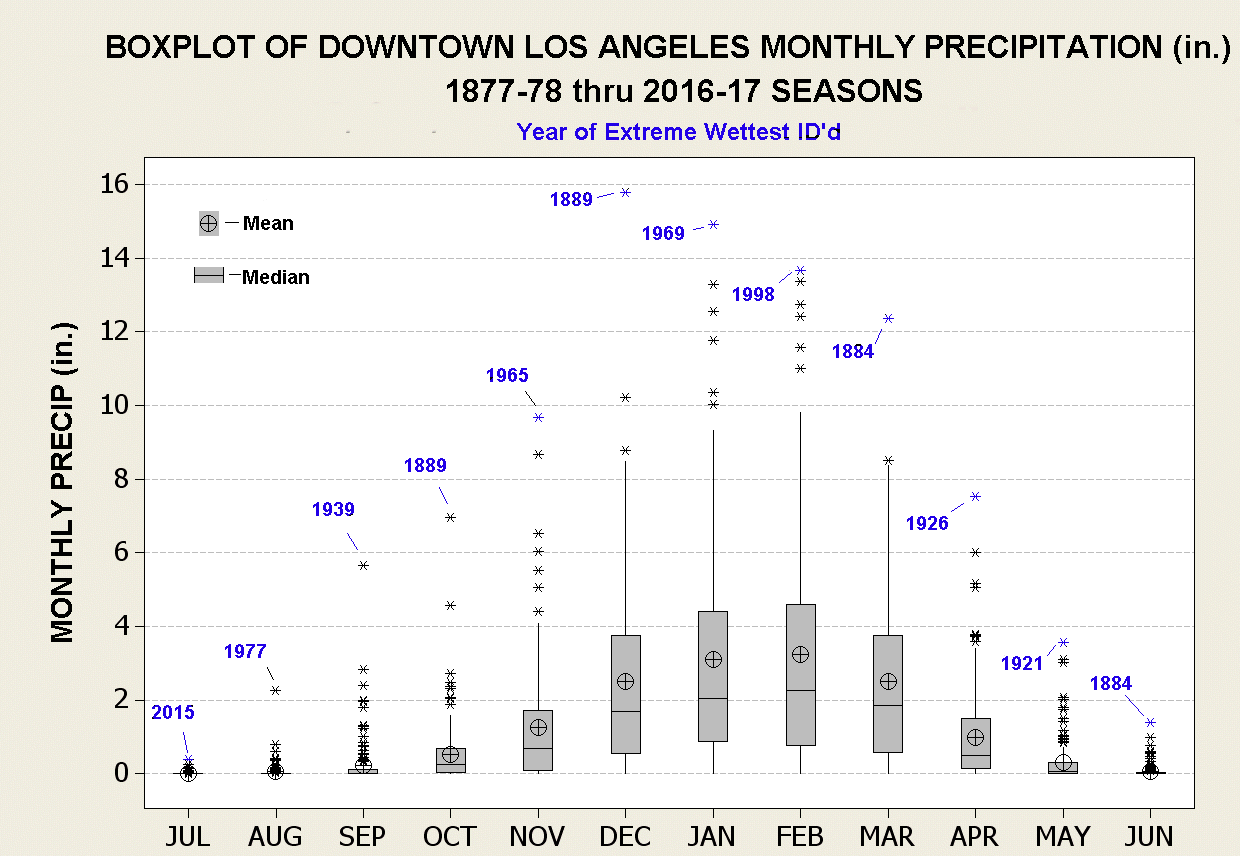
7:05pm Some meteorological background…
Southern California has two seasons: fire and rain. The fire season runs from the end of rain to the next rain. Winter is the rain season. Here is how rainfall usually looks:
Here is how Santa Ana winds look, by month at Pt. Magu, but pretty much everywhere in SoCal:

The problem is that there has been almost no rain so far in SoCal. So the fire season has been extended into the height of the Santa Ana wind season. A perfect storm of factors.
6:56pm Here is the Sunset Fire evacuation map, from https://lafd.org/news:

6:42:pm This is the flight path of N43CU, a Boeing Chinook, which I assume is an air tanker gathering water from the reservoir and dumping it on the Sunset Fire:

6:41pm Via FlightRadar24, here is the flight path of Fire 1, of the Los Angeles Fire Department:

6:28pm Here are views from Mt. Wilson Observatory. There is no coverage of this, but cleary fire is on the south slopes of the mountain. I have reports that KUSC/91.5, which transmits from Mt. Harvard (a peak on the city side), is off the air there. A friend who works at KNBC/4’s transmitter sent video of Mt. Harvard. That’s the one on the lower right:

6:16pm Via KNBC/4 is showing lots of traffic out while the fire trucks are trying to get in.
6:12pm Via KABC/7, the new Sunset Fire, is growing rapidly in Runyon Canyon, and vectored toward Hollywood Boulevard:

Evacuation is ordered from 101 to Mulholland to Laurel Canyon to Hollywood Boulevard. “Head south.”
3:25pm Via KABC/7. The Aldi is gone, along with many businesses on Lake in Altadena. One resident who lost a home: “The town is gone.”
Homes lost in Pacific Palisades, via the station helicopter (looking at my screen grabs):
- Many on Palisades Drive, including 1447 and 17055, currently on fire.
- Two houses, possibly including 1297 Palisades Drive, between that road and Santa Ynez Road, on fire.
- Many homes already burned (hard to tell) on Chastain Parkway West, including 16899, currently on fire.
- Two houses on Palisades Drive across from the intersection with El Basque Court, on fire. Others appear to be burned.
- Monte Hermosa Drive at Cumbre Alta Court, 16805 is on fire.
- Two houses on Palisades Drive, one is 1946, is on fire.
- 1846 Palisades Drive, on fire.
- At least one house on Paseo De Oro is on fire.
- 16899 Calle de Sarah is on fire.
3:10pm Another, of a U.S. Forest Service fixed-wing plane out of Burbank. These flight paths say something about where the action is:

Also:
- Beverly and Lake in Altadena: many fires, with helicopters dropping water or retardant
- Moonshadows in Malibu and many adjacent businesses and homes on Pacific Coast Highway are gone.
2:56pm Here is the flight path of a private aircraft out of Lancaster, CA:

I assume it has official business.
2:55pm A Ventura County fire helicopter, observing:

2:50pm on KABC/7:
- Mobile home park (surrounding Shore Drive) in Malibu across from the ocean is destroyed.
- Flaming homes on Mitwick in Altadena.
2:45 on KCAL/CBS:
- St. Marks Episcopal Church near Mariposa and Lake in Altadena, among other structures in the ‘hood, are gone.
2:34pm: watching FlightRadar24 to see what aircraft are on the case. Here is one:

2:31pm: KCAL/CBS is covering a new fire: Lydia.
2:30pm: SoCal Edison has a map of power outages.
2:15pm KCAL/CBS :
- The bungalows are gone at Palisades Charter High School, but the brick buildings are standing. Palisades Elementary is a total loss. Another elementary school is a partial loss.
- Homes on North Olive in Altadena are on fire.
- Chase Bank on Sunset in Pacific Palisades is engulfed in flames.
- Houses around El Molina and Sacramento Streets are down. Some are up.
- Fires at Allen and LaPaz Roads in Altadena.
2:00 on KABC/7 has this from their helicopter (going from maps superimposed on video):
- Many homes lost along Ramba Pacifico, Carbon Canyon Road, West Moon Shadows Drive, South Monte, in Pacific Palisades.
- Also along Palisades Drive, Verada de la Montura, Michael Lane, Avenue de la Herradura, Paseo Las Lomas.
- (on the ground) The Reel Inn, above Topanga Beach in Malibu, is gone. So are many houses in the area.
12:50 PM Listening to KNX/1070/97.1, the all-news station for Southern California. While the station now identifies as an FM station, its AM signal at night covers the entire southwest. You can get it well at night in Hawaii.
12:43 PM LAist/KPCC and KCOP/CBS News are working together. Items from that source:
- 21349 Rambla Vista in Malibu is a vantage on many destroyed homes on that street
- The Pasadena Waldorf School, at Highland and Altadena (which is close to the hearts and lives of many people we’ve known) is gone, along with most of the neighborhood.
12:33 PM The LA Times: Wildfire map
12:28 PM KTLA shows parts of Muir Heights in Altadena, on fire. This is west of the region above, closer to the 210 freeway.
12:13-12:25 PM CBS News Los Angeles:
- The Eaton Fire has jumped west into the center of Altadena
- The Altadena Senior Center is gone
- Christmas Tree Lane itself is being defended
- The Bunny Museum, at Lake and Altadena may be gone.
- The Big Rock district of Malibu has largely burned, and many of the houses along the Pacific Coast Highway below that have burned. “More gone than standing.”
- Dukes in Malibu is a fire staging area. Many have taken refuge there.
- Lack of water is an issue in many places, given continuous demand from fire fighting
Here is the FIRMS map of the Los Angeles fires, as of 7:50am Pacific time:

Here is a close-up of the Palisades fire as of about an hour ago:

Here is the Eaton Fire:

And here is the Sylmar Fire:

A request to TV stations covering the fires: tell us your exact locations when you are showing burning structures. I thank KABC/7 for reporting at length from these locations:
- Creekside Court and Dove Creek Lane in Altadena’s Eaton Canyon, west of Eaton Wash and south of New York Avenue
- Startouch Drive in Pasadena
- Palisades Village and Palisades Charter High School (the latter of which is gone)
- Pacific Coast Highway on the shore sides of Pacific Palisades and Malibu. Much here has burned
Leave a Reply