I’m listening to WGBH on 93.7 from Boston on my kitchen radio, on the low floor of an apartment building in Manhattan, thanks to an atmospheric condition called tropospheric bending, or “tropo” for short. Here’s my section of the current map of tropo at work right now:
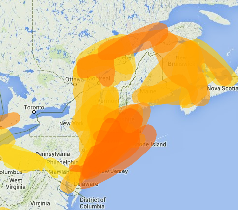 The same map shows bigger “ducts” running from Florida to Iowa and Missouri to California. The map is by John Harder, aka @ng0e. Other maps by meteorolgist William Harper abound here.
I would have loved the same thing back when I was (like John) a “DXer” who logged about a thousand different FM stations from my house in the woods north of Chapel Hill, North Carolina, in the late ’70s. “Tropo” showed up in the mornings, and another more dramatic form of long-distance propagation called “sporadic E” would appear in the afternoon and evenings, mostly in the late spring and early summer. Here’s a map source for that one.
One entertaining thing about sporadic E was how it affected channels 2-6 television. I picked up every Channel 3 in a circle that ran from Louisiana, across the prairie states, southeastern Canada, the Maritimes, and then around to Cuba. That whole band is now abandoned in the U.S. TV stations with those channel numbers actually radiate on other ones, while still occupying their old channels virtually. Also, we have the Internet, so watching and listening to faraway stations lacks the old thrill.
Still, it’s fun to hear that faraway stuff showing up every once in awhile.
Leave a Reply